|
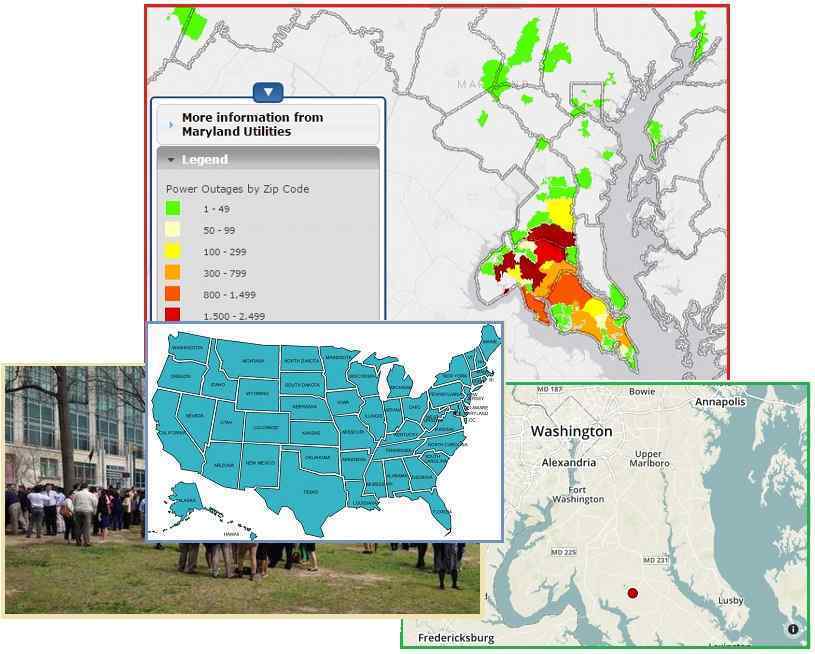
DC Goes Dark
Barely a week after Europe was struck by electromagnetic pulse
- crashing the Germanwings plane into the foothills of the Alps,
closing down CERN temporarily with a short-circuit near one if
its magnets, creating a blackout in Amsterdam and another in
Turkey, and creating multiple electrical fires under the streets
of London – Washington DC had its own blackout. The immediate
reaction was very revealing as to cause. A power surge
was cited (when broken equipment causes a brownout, a
voltage drop) and the authorities cast around for a problem to
blame, claiming an “explosion” for some time before a small fire
was finally located. Conspiracy forums watching the story unfold
noted that no utility posted any equipment problems on their
websites, nor were there any local reports of fires or alarms .
The blackouts also did not follow grid lines. Clearly, this was
an electromagnetic pulse.

- Outages Hit White House, Smithsonian,
U. Md
April 8, 2015
http://www.nbcwashington.com/news/local/Scattered-Power-Outages-Reported-in-Across-DC
- An equipment failure at a SMECO
power substation in Charles County appears to have caused
the outages. A Pepco high-voltage transmission conductor
at the substation fell to the ground, according to SMECO.
Pepco confirmed it is investigating exactly why that
transmission line broke. A back up system that senses low
voltage, which are purposely sensitive and designed to
sense risk, did their job, and switched over to back up.
- Power Surge Knocks out Electrical
Service in Parts of D.C. Region
April 7, 2015
http://www.washingtonpost.com/local/scattered-power-outages-reported-across-dc-area
- A power surge temporarily knocked
out power to the White House, State Department and wide
swaths of the nation’s capital and its Maryland suburbs.
D.C. homeland security officials, utility providers and
law enforcement officers in Charles County, Md., said a
fire or explosion at an electrical facility in Southern
Maryland appeared to be the source of the surge.
- Power Station Problem in Maryland
causes Outages across DC
April 7, 2015
http://bigstory.ap.org/article/5fbc4026ce0f463497c304383eec04f8/white-house
- The mechanical failure occurred
shortly before 1 p.m. at a transfer station some 35 miles
southeast of Washington in Charles County, Maryland, that
is controlled by utilities serving Washington and southern
Maryland. Homeland security officials in Washington and
Maryland said there was an explosion at the station,
although the two utilities, Pepco and the Southern
Maryland Electric Cooperative, could not immediately
confirm that there was a blast or fire.
- Power Surge Knocks out Electrical
Service in Parts of D.C. Region
April 7, 2015
http://www.washingtonpost.com/local/scattered-power-outages-reported-across-dc-area
- A piece of metal breaking loose
from a power line 43 miles southeast of the District
momentarily knocked out electricity. The outage threw
scores of public and private office buildings off the
grid, but in most cases, the lights stayed on because
backup generators kicked in. Dotter said the fluctuation
in the voltage probably left some in the D.C. area
experiencing a power loss and others a power surge. D.C.
Homeland Security and Emergency Management Agency
characterized the unusual incident as a broad “power
surge” that sent any District facility with a critical
operation to emergency backup power. A Pepco transmission
conductor in Mechanicsville, Md., “broke free from its
support structure and fell to the ground.” The failure on
the 230,000-kilovolt Pepco line cut the supply to two
power stations run by SMECO.
ZetaTalk Insights
4/11/2015: There
are several clues that the DC region blackout was caused by
electromagnetic pulse. The first was the casual and quick
manner in which officials announced it was not terrorism, even
before they were able to point to a cause. They knew it was
electromagnetic pulse, but were not admitting this to the
public. The second clue is the repeated statement by officials
that the blackout was due to a surge, when this is not how the
grid and its protective mechanisms work. A surge happens
during an electromagnetic pulse, but a failure in the grid
causes a voltage drop, a brownout. The third clue is the wide
ranging and spotty nature of the blackouts, which did not
follow a grid but rather affected a region.
Why was Washington DC
affected? It is situated in lowlands, known in the early days
of the republic as “foggy bottom” for that reason, a swampland
which had to be drained so the mosquito population could be
controlled. It is situated at a tear point during a time when
the N American Continent is in a taut bow, the bow ends at the
Aleutian Islands and the tip of Mexico pulling toward each
other. The center of the bow is at San Diego. Follow the line
across the continent and you arrive at Washington DC.
Chesapeake Bay is an obvious rip point where tears have
occurred in the past. Will more such blackouts afflict the
East Coast of the US? These electromagnetic pulse episodes
have just started, and depending upon their vulnerability,
will increasingly afflict cities worldwide.
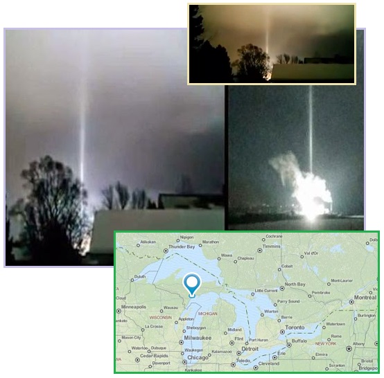
The N American bow stress has created booms, hums, and crevasses
along the St. Lawrence Seaway. A recent example was the Escanaba
lights detailed in Issue 438 of this
newsletter.
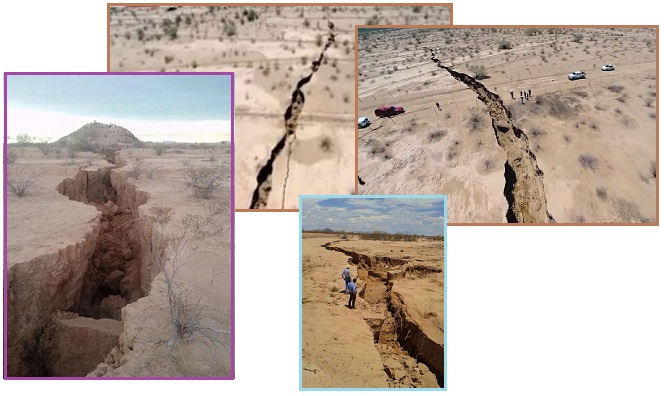
Booms from snapping rock are heard coast to coast, as this chart
in Issue 434 of this newsletter
shows. Dramatic crevasses in Mexico have recently appeared, as
detailed in Issue 416 this
newsletter. And unexplained train derailments across the
continent are occurring, as Issue 381
of this newsletter details.
Cheyenne Mountain
Returns
An announcement that NORAD was going to be returning to
Cheyenne Mountain was published on the same DAY as the
Washington DC blackout. This was likely a coincidence, but it
certainly demonstrates a concern in the US military.
Electromagnetic pulse is on the increase, and they are taking
the ZetaTalk predictions seriously. When the blackout hit
Washington DC, they were likely not surprised. They knew these
incidents were going to occur. Cheyenne Mountain was
vacated in 2006 for lack of space, but now the fact that
Cheyenne Mountain is protected from electromagnetic pulse seems
more important.

- US Aerospace Command moving Comms Gear
back to Cold War Bunker
April 7, 2015
http://news.yahoo.com/us-aerospace-command-moving-comms-gear-back-cold
- In 2006, officials decided to move
the headquarters of NORAD and US Northern Command from
Cheyenne to Petersen Air Force base in Colorado Springs.
The Cheyenne bunker was designated as an alternative
command center if needed. That move was touted a more
efficient use of resources but had followed hundreds of
millions of dollars worth of modernization work at
Cheyenne carried out after the attacks of September 11,
2001. Now the Pentagon is looking at shifting
communications gear to the Cheyenne bunker
- Why is the US Military moving back
into 'Stargate' base deep under the Rocky Mountains a Decade
after it was Abandoned?
April 8, 2015
http://www.dailymail.co.uk/news/article-3031041/Why-military-moving-Stargate-base
- The Cheyenne Mountain Complex is
one of the icons of the Cold War - a self-contained and
sufficient town buried under the Rockies meant to be
impervious to a Soviet nuclear barrage. It was home to the
North American Aerospace Command (NORAD), scanning the
skies for Russian missiles and the military command and
control center of the United States in the event of World
War Three. The high tech base entered popular culture with
appearances in the 1983 Cold War thriller War Games and
1994's Stargate - which imagined the complex as a
clandestine home for intergalactic travel. Cheyenne
Mountain will once again be home to the most advanced
tracking and communications equipment in the United States
military. The shift to the Cheyenne Mountain base in
Colorado is designed to safeguard the command's sensitive
sensors and servers from a potential electromagnetic pulse
(EMP) attack, military officers said. Admiral William
Gortney, head of NORAD and Northern Command, said that
'because of the very nature of the way that Cheyenne
Mountain's built, it's EMP-hardened.'
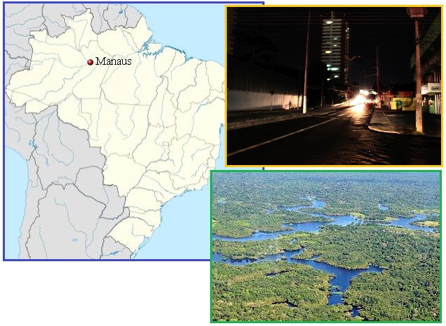
Amazon Goes Dark
Having hopped the Atlantic from Europe to Washington DC, the
charged and wafting tail of Nibiru, aka Planet X struck S
America too. In Manaus in the Amazon basin, at the confluence of
the Negro and Solimões rivers, an unexplained blackout occurred.
Once again, in soggy lowlands, in the heart of a continent
subject to being torn apart as the top of S America rolls to the
west.
- Blackout reaches 50% of Manaus
April 9, 2015
http://g1.globo.com/am/amazonas/noticia/2015/04/apagao-afeta-distribuicao-de-agua
- A blackout hit several areas of
Manaus late on Thursday (4/9). According Eletrobras
Amazonas Energia information, the shutdown of transmission
lines left about 50% of the capital without the supply of
electricity. The fall in energy supply started at 19.15
after the shutdown of the 500 kV lines.
- Manaus
http://en.wikipedia.org/wiki/Manaus
- It is situated at the confluence
of the Negro and Solimões rivers. Manaus is located in the
middle of the Amazon rainforest, and access to the city is
primarily through boat or airplane.
The blackout occurred, once again, on the same day
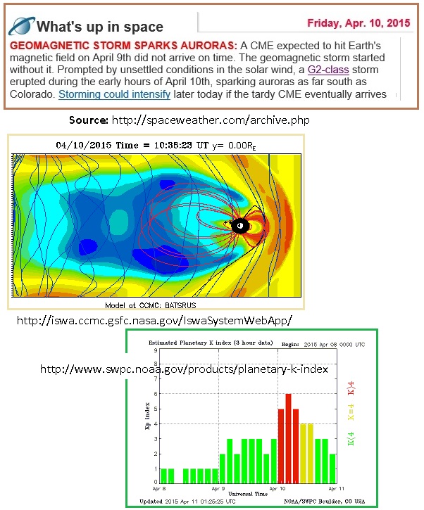
a strong magnetic blast from the magnetic N Pole of Planet X,
aka Nibiru was recorded, as a dedicated blog on the Pole
Shift ning noted. Attempts to blame the Sun faltered
as the blast occurred before a predicted impact from a moderate
CME could possibly have traveled to Earth. Once again, the
Zetas, in their predictions, right again.
ZetaTalk Comment
3/21/2015: Anyone
watching the trends has noted that airplanes losing electronic
control and crashing into the sea below is on the increase.
Electro-magnetic blasting from the charged tail of Planet X,
aka Nibiru, is also causing blackouts, which go unexplained to
the public who are suddenly cast into darkness. The magnetic
push from the hose of magnetons coming from the N Pole of
Planet X is also what is causing the daily Earth wobble. Even
after the approach and pending passage of Nibiru is explained
to the public, there will be a cover-up on what is causing the
Earth’s erratic weather, the daily wobble, and electromagnetic
disasters. NASA has been blaming the Sun for these
effects, but lately during the Solar Minimum their timing has
been off. They hope to get advanced warning, to improve the
timing of their lies.
ZetaTalk Prediction
6/1/2002: Any
reason for the current weather, satellite failure, magnetic
diffusion, or heating core along with volcanic and quake
increases, are to be blamed on the Sun or Global Warming, or
normal cycles detected in the past, causing Ice Ages or
melting poles in history. The common man, exhausted after a
long day earning a living, and not educated enough to
challenge some of the sources of news, is confused. Will this
continue up until the shift? Yes, and get worse, until the
barrage of disinformation is overwhelming.
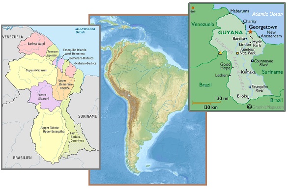
Following the Amazon blackout Guyana had a blackouts throughout
the majority of the country, across several regions. These
blackouts were described as “intermittent” and blamed on minor
mechanical problems in one region and a car crashing into a pole
for others. What is Guyana Power and Light Inc. to say - “it
came from outer space”? Note that the blackouts ran along the
main river into the Amazon basin in the interior, another rip
point for the rolling S American continent as it rolls.
- Darkness Inside, Darkness Outside,
Darkness Everywhere
April 14, 2015
http://www.kaieteurnewsonline.com/2015/04/14/darkness-inside-darkness-outside-darkness-everywhere/
- Region Six had blackouts. We
traveled back to Georgetown in total darkness – Regions
Five and Four and parts of Region Three had blackouts. GPL
said the cause was a driver hit a utility pole. So almost
half of Guyana can get electricity disruption through the
mere destruction of a pole. Do you believe
that?
- Canter Truck Sparks Berbice/Demerara
Blackouts
April 15, 2015
http://www.kaieteurnewsonline.com/2015/04/14/canter-truck-sparks-berbicedemerara-blackouts/
- The Guyana Power and Light Inc.
(GPL) say that a truck accident caused Sunday night’s
massive power outage which left several parts of the
coastlands in Berbice and Demerara without power.
At approximately 20:18 hrs on Sunday, a Canter truck
travelling east along the railway embankment crashed and
broke a pole at Mon Repos supporting a primary 69 kv
transmission line linking the Demerara and Berbice
systems, resulting in a Demerara Berbice Interconnected
System (DBIS) shutdown. According to GPL, due to a
defective breaker, two further shutdowns were experienced
during attempts of power restoration. Meanwhile, in
Essequibo, the Number One Wartsila Unit and Caterpillar
generating set at Anna Regina experienced some minor
mechanical issues over the past weekend resulting in brief
intermittent outages in that area.
ZetaTalk Respected
Though rarely admitted, the wealthy elite and those in the
halls of power have long taken the ZetaTalk predictions
seriously. Lately, this has been shown by their actions.
For instance, NORAD moving back into Cheyenne Mountain for the
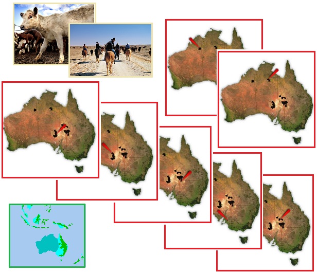
electromagnetic protection. For instance, a huge family held
cattle ranch in Australia suddenly being put on the market. They
are rushing to sell all,
just ahead of the announcement wherein ZetaTalk will be credited
with pointing to Nibiru as it entered the solar system in 2003.
What else might
ZetaTalk have predicted? Oh, that the western 2/3 of Australia
will be driven under the waves during the hour of the Pole
Shift! And what would this do to S.
Kidman & Co Ltd? Business is booming, their grass fed
cattle in demand worldwide, but suddenly they must sell all!
- Australian Company Selling the World’s
biggest Cattle Property
April 10, 2015
http://news.nationalpost.com/news/world/australian-company-selling-the-worlds-biggest-cattle-property
- Family shareholders, who hold 98%
of the company founded in 1899, are selling livestock,
plant and property. The sale represents a decision “to
capitalize on the present demand for quality Australian
agricultural assets,” Managing Director Greg Campbell said
in the statement. “Many of the family have other existing
investments in Australian agriculture and elsewhere and
the sale will allow them to convert long-term capital
gains into cash to support their other businesses and
investments.”
- World's Largest Cattle Station is on
the Market
April 12, 2015
http://www.dailymail.co.uk/news/article-3034567/What-23-000-square-kilometres-Australian
- The largest of the stations is
Anna Creek Station in South Australia. All of the
farms include the original equipment as well as the stock
which is a beneficial deal with the 11 properties
currently have 155,000 branded cattle with 30,000 more
calves on the way. Other stations for sale in Queensland
include Durham Downs, Durrie, Glengyle, Morney Plains,
Naryilco and Rockybank. Western Australia offers
Innamincka, Macumba and Tungali in South Australia; Helen
Springs in the Northern Territory and Ruby Plains.
- Anna Creek Station
http://en.wikipedia.org/wiki/Anna_Creek_Station
- Anna Creek Station is the world's
largest working cattle station. It is located in the
Australian state of South Australia. Its area is roughly
6,000,000 acres which is slightly larger than Israel. The
nearest township is William Creek (which is surrounded by
the Anna Creek station).
ZetaTalk Prediction
2001: Australia
will be in a good and bad situation re the pole shift. The
western 2/3 will go suddenly under water, due to the plate
shared with Indian sliding under the Himalayas. The western
half of Australia will suddenly go under the waves. This will
seem, to the stunned residents, as though a tidal wave were
steadily moving inland, and where the crest of the wave will
not at first be high, the waters will just keep rising until
all not afloat are drown.
If the western 2/3 of Australia is to be avoided, what about the
newly tropical lands in Canada and Russia’s Far East? We have
already documented how Russia is moving to their Far East, as
detailed in Issue 417 of this
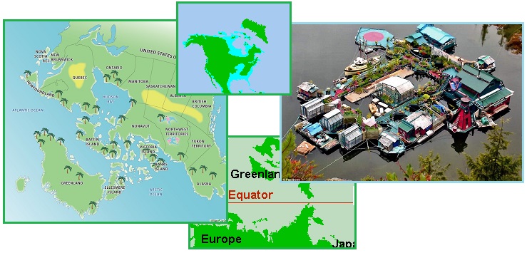
newsletter. What can Canada anticipate? Perhaps a tropical
island paradise! Note the reference to the poles being reversed.
Note the attention that houseboat living is getting these days,
as this latest situated in Vancouver, Canada. Where the new
Equator will pass by what is now northern Canada, there will be
much flooding of Canadian lowlands. They know!
- This Upside-Down Canada Map looks like
a Tropical Paradise
April 10, 2015
http://www.huffingtonpost.ca/2015/04/10/canada-upside-down-map
- Toronto-based data visualizer
William Davis posted the map to Reddit today, and it shows
Canada's north looking like a tropical paradise, compared
to its south. Regions such as Baffin Island and the
Northwest Territories look like Caribbean destinations, as
does Ontario's north. Davis said on Reddit that the map
was inspired by the "horrible winter" that had taken hold
in central and Eastern Canada. Now if only Earth could
somehow reverse its poles, we'd be booking an
all-inclusive vacation to Ellesmere Island.
- This is how to REALLY Get Away from it
All
April 12, 2015
http://www.dailymail.co.uk/news/article-3035438/Family-lives-AMAZING
- A Canadian couple have ditched
busy city life to live on a colorful off-the-grid
float-home and garden they've dubbed 'Freedom Cove' - a
completely self-sustainable float home consisting of 12
platforms that houses wooden structures, green houses and
living spaces all interconnected through a wooden
pathway. During winter months, the couple collect
rainwater for drinking and in the summer they collect
drinking water from a nearby freshwater waterfall across
the bay. They have several greenhouses in which the
family grows fruit and vegetables year
round. Electricity is supplied to the home through
solar panels and photovoltaic energy generators.
ZetaTalk Prediction
7/15/1995: The
pole shift, with consequent realignment of the poles, will
place the New Equator over formerly frozen lands. Greenland,
Canada, Alaska, Siberia, and Europe will be affected by the
new equator. This will not mean that these areas will be lush,
right away. The temperate zones, not all that lush to begin
with, will find themselves after the cataclysms in a warm
state, but with little vegetation. Past cataclysms have
regularly rearranged the Earth's geography and climate zones,
as the Earth attests. The continents, once one large land
mass, were torn apart, temperate or tropical areas suddenly
freezing up and covering over with ice and snow that never
melts, and frozen wastelands gradually melting and warming to
sustain life once again. Mountains in mountain building areas
were pushed higher and subducting plates were suddenly slid
under the overplate.
ZetaTalk Prediction
2001: The
worry Canadians should be concerned about is one that will
sneak up on them, in the days leading into the pole shift and
in the two years following. Much of Canada has a low altitude,
and where land lies lower than 650 to 700 feet, this will be
inundated within two years due to the melting ice caps of the
old poles, now under the equatorial sun. Much of Canada is low
lying land. If one examines the sea level of land in eastern
or northern Canada, one can see that the land will not be
above water when the poles have completely melted. If situated
in an area due to be inundated, survivors will have to
repeatedly move ahead of the encroaching water, and take care
they are not trapped on an island in the process!
|

