| |
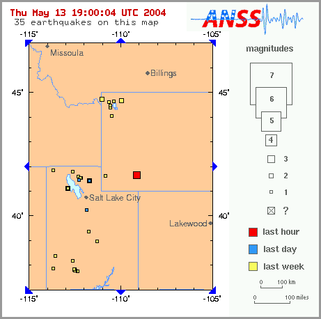 The map at right depicts a 3.2 magnitude Wyoming earthquake which was reported
as happening at 2:40 PM EDT today, and then within an hour, mention of it
disappeared from the USGS seismic reporting site. Oddly enough, while the "Red
Square" shown has disappeared, some data on the quake is still available Online. If
and when that URL no longer works, here is the information shown there now:
The map at right depicts a 3.2 magnitude Wyoming earthquake which was reported
as happening at 2:40 PM EDT today, and then within an hour, mention of it
disappeared from the USGS seismic reporting site. Oddly enough, while the "Red
Square" shown has disappeared, some data on the quake is still available Online. If
and when that URL no longer works, here is the information shown there now: Recent Earthquake Activity in the USA
Magnitude 3.2 - WYOMING
2004 May 13 18:40:21 UTC
Preliminary Earthquake Report
University of Utah Seismograph Stations
A minor earthquake occurred at 18:40:21 (UTC) on Thursday, May 13, 2004. The magnitude 3.2 event has been located in WYOMING. The hypocentral depth was poorly constrained. (This is a computer-generated message -- this event has not yet been reviewed by a seismologist.)
Magnitude 3.2
Date-Time Thursday, May 13, 2004 at 18:40:21 (UTC)
= Coordinated Universal Time
Thursday, May 13, 2004 at 12:40:21 PM
= local time at epicenter
Location 41.665°N, 109.150°W
Depth 1 km (~0.6 mile) (poorly constrained)
Region WYOMING
Distances 5 km (3 miles) E (89°) from Reliance, WY
10 km (6 miles) E (79°) from North Rock Springs, WY
10 km (6 miles) NE (36°) from Rock Springs, WY
251 km (156 miles) ENE (65°) from Salt Lake City, UT
Location Uncertainty horizontal +/- 7.3 km (4.5 miles); depth +/- 56.3 km (35.0 miles)
Parameters Nst= 27, Nph= 27, Dmin=176 km, Rmss=1.01 sec, Gp=212°,
M-type=local magnitude (ML), Version=1
Source University of Utah Seismograph Stations
Event ID uu00004230